
Road vs street
Historically, Ivy Road is associated with an affluent way of life, from large agrarian land holdings, plantations and the legacy of slavery, to early and mid-twentieth-century subdivisions such as Bellair with restrictions on race and religion. Examining the site today, from the intersection of Emmet and Ivy to Boar’s Head Inn, it is difficult to imagine this forgotten passageway as a once wealthy rural entrance to UVA.
As Dean Meyer mentioned in her opening address to Vortex 2015 Kickoff Monday afternoon, this project would transform the notion of Ivy from a road to a street. A road is defined as “a hard flat surface for vehicles, people and animals to travel on, especially one lying outside of an urban district.”[1] In contrast, a street is “a thoroughfare especially in a city, town, or village that is wider than an alley or lane and that usually includes streets.”[2] The history of Ivy Road embodies the rural understanding of a road, as a pastoral western entry to Grounds.
Sections of Ivy Road still align with Virginia’s Three Notch’d Road; which if you’re unfamiliar with the name, asides from the brewery, is a historic road that was marked with three notches in trees for travelers moving east to west across Virginia. As transportation progressed along with the twentieth century, the road was paved and linked with US 29 with a bypass, increasing traffic and the use of Ivy Road as an approach to the university. With this growth, the area shifted once again, as a response to the housing expansion post World War II.
Two rather simple terms used to describe Ivy Road have effectively connected images of the past and future to each word. As this Vortex explores the historical past and the peri-urban landscape—neither urban nor rural—but both, it welcomes in a new future by changing its concept from a road into a street. The name of Ivy Road isn’t replacing road with street, it’s the perception of the corridor that will be evolving. Moving forward, this project would create an alternative entrance to the university, one that emphasizes student residential life in a different and unique way than the eastern entry from the train station. Albeit an untraditional way to come upon the university, it continues in Jeffersonian language by once again placing an academical village at the forefront point of access to Grounds.
Our visions as a design institution would dramatically change the viewshed along Ivy Road in an exciting and unprecedented way for UVA. To read more about the history and timeline of Ivy, go to http://250west.neatline-uva.org/vortex and be sure to choose “How to Use This Site” to maximize information from the site.
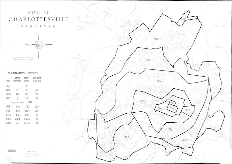
History of Annexations- Charlottesville-Showing the growth and land acquisition by the city.
Sources: UVA Facilities and Management Geospatial Engineering Services Archive
[1] http://www.merriam-webster.com/dictionary/road
[2] http://www.merriam-webster.com/dictionary/street
-Margaret Stella (M.Arh.)
As Dean Meyer mentioned in her opening address to Vortex 2015 Kickoff Monday afternoon, this project would transform the notion of Ivy from a road to a street. A road is defined as “a hard flat surface for vehicles, people and animals to travel on, especially one lying outside of an urban district.”[1] In contrast, a street is “a thoroughfare especially in a city, town, or village that is wider than an alley or lane and that usually includes streets.”[2] The history of Ivy Road embodies the rural understanding of a road, as a pastoral western entry to Grounds.
Sections of Ivy Road still align with Virginia’s Three Notch’d Road; which if you’re unfamiliar with the name, asides from the brewery, is a historic road that was marked with three notches in trees for travelers moving east to west across Virginia. As transportation progressed along with the twentieth century, the road was paved and linked with US 29 with a bypass, increasing traffic and the use of Ivy Road as an approach to the university. With this growth, the area shifted once again, as a response to the housing expansion post World War II.
Two rather simple terms used to describe Ivy Road have effectively connected images of the past and future to each word. As this Vortex explores the historical past and the peri-urban landscape—neither urban nor rural—but both, it welcomes in a new future by changing its concept from a road into a street. The name of Ivy Road isn’t replacing road with street, it’s the perception of the corridor that will be evolving. Moving forward, this project would create an alternative entrance to the university, one that emphasizes student residential life in a different and unique way than the eastern entry from the train station. Albeit an untraditional way to come upon the university, it continues in Jeffersonian language by once again placing an academical village at the forefront point of access to Grounds.
Our visions as a design institution would dramatically change the viewshed along Ivy Road in an exciting and unprecedented way for UVA. To read more about the history and timeline of Ivy, go to http://250west.neatline-uva.org/vortex and be sure to choose “How to Use This Site” to maximize information from the site.
History of Annexations- Charlottesville-Showing the growth and land acquisition by the city.
Sources: UVA Facilities and Management Geospatial Engineering Services Archive
[1] http://www.merriam-webster.com/dictionary/road
[2] http://www.merriam-webster.com/dictionary/street
-Margaret Stella (M.Arh.)